


2016 09 24 ÎLE DE SEIN

rousseau.mich
User
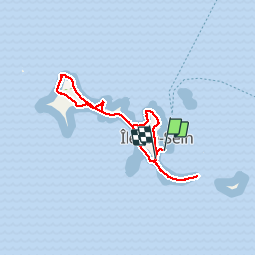

Length
6.2 km

Max alt
7 m

Uphill gradient
18 m
Km-Effort
6.5 km

Min alt
0 m

Downhill gradient
19 m
Boucle
Yes
Creation date :
2016-09-26 00:00:00.0
Updated on :
2016-09-26 00:00:00.0
2h15
Difficulty : Very easy

FREE GPS app for hiking
 SityTrail
IGN / Geographical institutes
SityTrail Plus
The world is yours!
About
Trail Walking of 6.2 km to be discovered at France. This trail is proposed by rousseau.mich.
Positioning
Country:
France
Region :
BRETAGNE
Department/Province :
FINISTERE
Municipality :
ILE-DE-SEIN
Location:
Unknown
Start:(Dec)
Start:(UTM)
362116 ; 5321901 (30U) N.
Comments