


Montclus dent du serret

pierre.chau
User
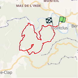

Length
16.4 km

Max alt
323 m

Uphill gradient
546 m
Km-Effort
24 km

Min alt
90 m

Downhill gradient
521 m
Boucle
No
Creation date :
2016-09-24 00:00:00.0
Updated on :
2016-09-24 00:00:00.0
5h03
Difficulty : Medium

FREE GPS app for hiking
 SityTrail
IGN / Geographical institutes
SityTrail Plus
The world is yours!
About
Trail Walking of 16.4 km to be discovered at Occitania, Gard, Montclus. This trail is proposed by pierre.chau.
Positioning
Country:
France
Region :
Occitania
Department/Province :
Gard
Municipality :
Montclus
Location:
Unknown
Start:(Dec)
Start:(UTM)
613298 ; 4901994 (31T) N.
Comments