


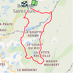
randonnée des 1000 Etangs ( version raccourcie )

nicolasdresse
User

Length
7.9 km

Max alt
707 m

Uphill gradient
217 m
Km-Effort
10.8 km

Min alt
596 m

Downhill gradient
232 m
Boucle
Yes
Creation date :
2018-09-29 20:52:27.087
Updated on :
2018-09-29 20:52:27.155
2h23
Difficulty : Easy

FREE GPS app for hiking
 SityTrail
IGN / Geographical institutes
SityTrail Plus
The world is yours!
About
Trail Walking of 7.9 km to be discovered at Bourgogne-Franche-Comté, Haute-Saône, Beulotte-Saint-Laurent. This trail is proposed by nicolasdresse.
Photos
 - Photo 1")
 - Photo 2")
 - Photo 3")
 - Photo 4")


Positioning
Country:
France
Region :
Bourgogne-Franche-Comté
Department/Province :
Haute-Saône
Municipality :
Beulotte-Saint-Laurent
Location:
Unknown
Start:(Dec)
Start:(UTM)
326522 ; 5303387 (32T) N.
Comments