


AUTEUIL PONT DE SEVRES

olivieraron
User
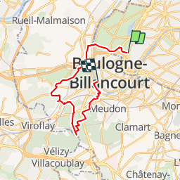

Length
20 km

Max alt
188 m

Uphill gradient
374 m
Km-Effort
25 km

Min alt
13 m

Downhill gradient
384 m
Boucle
No
Creation date :
2019-01-14 09:44:21.209
Updated on :
2019-01-14 09:44:21.291
7m
Difficulty : Unknown

FREE GPS app for hiking
 SityTrail
IGN / Geographical institutes
SityTrail Plus
The world is yours!
About
Trail Other activity of 20 km to be discovered at Ile-de-France, Paris, Paris. This trail is proposed by olivieraron.
Positioning
Country:
France
Region :
Ile-de-France
Department/Province :
Paris
Municipality :
Paris
Location:
16th Arrondissement
Start:(Dec)
Start:(UTM)
445660 ; 5410831 (31U) N.
Comments