


Arbois 20160923

cmike39
User
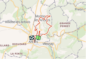

Length
12.7 km

Max alt
539 m

Uphill gradient
360 m
Km-Effort
17.5 km

Min alt
284 m

Downhill gradient
358 m
Boucle
Yes
Creation date :
2017-04-14 00:00:00.0
Updated on :
2020-07-26 20:03:00.099
3h44
Difficulty : Unknown

FREE GPS app for hiking
 SityTrail
IGN / Geographical institutes
SityTrail Plus
The world is yours!
About
Trail Walking of 12.7 km to be discovered at Bourgogne-Franche-Comté, Jura, Arbois. This trail is proposed by cmike39.
Description
Martine M.
Positioning
Country:
France
Region :
Bourgogne-Franche-Comté
Department/Province :
Jura
Municipality :
Arbois
Location:
Unknown
Start:(Dec)
Start:(UTM)
711375 ; 5198013 (31T) N.
Comments