


2016-09-26 Plougnonvolin Finistère

rousseau.mich
User

Length
5.4 km

Max alt
52 m

Uphill gradient
100 m
Km-Effort
6.7 km

Min alt
0 m

Downhill gradient
100 m
Boucle
Yes
Creation date :
2016-09-26 00:00:00.0
Updated on :
2016-09-26 00:00:00.0
1h39
Difficulty : Very easy

FREE GPS app for hiking
 SityTrail
IGN / Geographical institutes
SityTrail Plus
The world is yours!
About
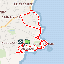
Trail Walking of 5.4 km to be discovered at Brittany, Finistère, Plougonvelin. This trail is proposed by rousseau.mich.
Positioning
Country:
France
Region :
Brittany
Department/Province :
Finistère
Municipality :
Plougonvelin
Location:
Unknown
Start:(Dec)
Start:(UTM)
373541 ; 5355202 (30U) N.
Comments