


Pannessiéres

drarep
User
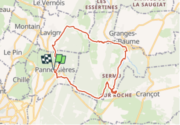

Length
15.3 km

Max alt
559 m

Uphill gradient
507 m
Km-Effort
22 km

Min alt
287 m

Downhill gradient
507 m
Boucle
Yes
Creation date :
2016-09-26 00:00:00.0
Updated on :
2022-11-09 17:13:30.556
4h44
Difficulty : Medium

FREE GPS app for hiking
 SityTrail
IGN / Geographical institutes
SityTrail Plus
The world is yours!
About
Trail Walking of 15.3 km to be discovered at Bourgogne-Franche-Comté, Jura, Pannessières. This trail is proposed by drarep.
Description
Reconnaissance Bernard AMB
Positioning
Country:
France
Region :
Bourgogne-Franche-Comté
Department/Province :
Jura
Municipality :
Pannessières
Location:
Unknown
Start:(Dec)
Start:(UTM)
698561 ; 5174978 (31T) N.
Comments