


Fontaine Simon 12,61

togolo28
User
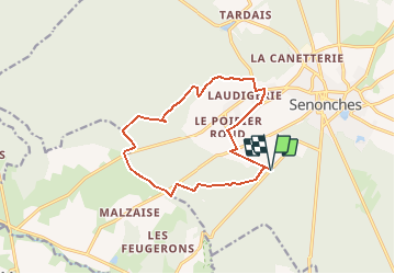

Length
12.6 km

Max alt
278 m

Uphill gradient
111 m
Km-Effort
14.1 km

Min alt
233 m

Downhill gradient
111 m
Boucle
Yes
Creation date :
2016-09-27 00:00:00.0
Updated on :
2016-09-27 00:00:00.0
3h06
Difficulty : Easy

FREE GPS app for hiking
 SityTrail
IGN / Geographical institutes
SityTrail Plus
The world is yours!
About
Trail Walking of 12.6 km to be discovered at Centre-Loire Valley, Eure-et-Loir, Senonches. This trail is proposed by togolo28.
Positioning
Country:
France
Region :
Centre-Loire Valley
Department/Province :
Eure-et-Loir
Municipality :
Senonches
Location:
Unknown
Start:(Dec)
Start:(UTM)
353525 ; 5378857 (31U) N.
Comments