


Piton de l'entonnoir

Fdum
User
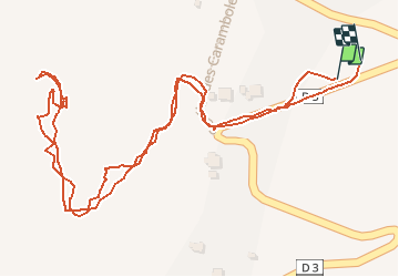

Length
1.3 km

Max alt
446 m

Uphill gradient
71 m
Km-Effort
2.3 km

Min alt
369 m

Downhill gradient
74 m
Boucle
Yes
Creation date :
2016-09-28 00:00:00.0
Updated on :
2016-09-28 00:00:00.0
36m
Difficulty : Easy

FREE GPS app for hiking
 SityTrail
IGN / Geographical institutes
SityTrail Plus
The world is yours!
About
Trail Walking of 1.3 km to be discovered at Réunion, Unknown, Saint-Joseph. This trail is proposed by Fdum.
Description
Point de vue au dessus de ST JOSEPH. Boucle possible.
Positioning
Country:
France
Region :
Réunion
Department/Province :
Unknown
Municipality :
Saint-Joseph
Location:
Unknown
Start:(Dec)
Start:(UTM)
356629 ; 7637746 (40K) S.
Comments