


2016 toussaint J3

Airelle
User
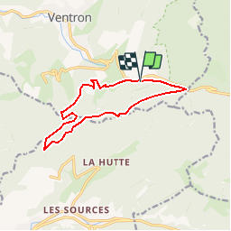

Length
11.5 km

Max alt
1079 m

Uphill gradient
504 m
Km-Effort
18.1 km

Min alt
756 m

Downhill gradient
489 m
Boucle
Yes
Creation date :
2016-10-17 00:00:00.0
Updated on :
2016-10-17 00:00:00.0
5m
Difficulty : Unknown

FREE GPS app for hiking
 SityTrail
IGN / Geographical institutes
SityTrail Plus
The world is yours!
About
Trail Walking of 11.5 km to be discovered at Grand Est, Vosges, Ventron. This trail is proposed by Airelle.
Positioning
Country:
France
Region :
Grand Est
Department/Province :
Vosges
Municipality :
Ventron
Location:
Unknown
Start:(Dec)
Start:(UTM)
343046 ; 5310113 (32T) N.
Comments