


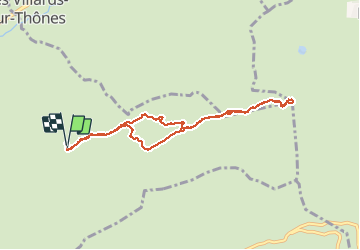
2016-10-01 Marche Pointe du Beauregard

holtzv
User GUIDE

Length
8.4 km

Max alt
1642 m

Uphill gradient
388 m
Km-Effort
13.6 km

Min alt
1301 m

Downhill gradient
398 m
Boucle
Yes
Creation date :
2016-10-02 00:00:00.0
Updated on :
2016-10-02 00:00:00.0
3h23
Difficulty : Easy

FREE GPS app for hiking
 SityTrail
IGN / Geographical institutes
SityTrail Plus
The world is yours!
About
Trail Walking of 8.4 km to be discovered at Auvergne-Rhône-Alpes, Upper Savoy, Thônes. This trail is proposed by holtzv.
Positioning
Country:
France
Region :
Auvergne-Rhône-Alpes
Department/Province :
Upper Savoy
Municipality :
Thônes
Location:
Unknown
Start:(Dec)
Start:(UTM)
295823 ; 5084999 (32T) N.
Comments