


CLD-le 21/06/2016

JackPG
User
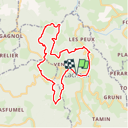

Length
16.8 km

Max alt
679 m

Uphill gradient
525 m
Km-Effort
24 km

Min alt
461 m

Downhill gradient
522 m
Boucle
Yes
Creation date :
2016-10-05 00:00:00.0
Updated on :
2016-10-05 00:00:00.0
4h59
Difficulty : Difficult

FREE GPS app for hiking
 SityTrail
IGN / Geographical institutes
SityTrail Plus
The world is yours!
About
Trail Walking of 16.8 km to be discovered at Auvergne-Rhône-Alpes, Puy-de-Dôme, Lachaux. This trail is proposed by JackPG.
Positioning
Country:
France
Region :
Auvergne-Rhône-Alpes
Department/Province :
Puy-de-Dôme
Municipality :
Lachaux
Location:
Unknown
Start:(Dec)
Start:(UTM)
545851 ; 5093617 (31T) N.
Comments