


Mont Valier

philou6351
User
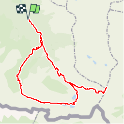

Length
25 km

Max alt
2809 m

Uphill gradient
2480 m
Km-Effort
58 km

Min alt
933 m

Downhill gradient
2480 m
Boucle
Yes
Creation date :
2016-10-09 00:00:00.0
Updated on :
2016-10-09 00:00:00.0
11h13
Difficulty : Unknown

FREE GPS app for hiking
 SityTrail
IGN / Geographical institutes
SityTrail Plus
The world is yours!
About
Trail Walking of 25 km to be discovered at Occitania, Ariège, Bordes-Uchentein. This trail is proposed by philou6351.
Points of interest


Positioning
Country:
France
Region :
Occitania
Department/Province :
Ariège
Municipality :
Bordes-Uchentein
Location:
Les Bordes-sur-Lez
Start:(Dec)
Start:(UTM)
339010 ; 4744220 (31T) N.
Comments