


Mont St Odile ok

LaurentGILG
User
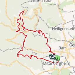

Length
21 km

Max alt
812 m

Uphill gradient
871 m
Km-Effort
32 km

Min alt
226 m

Downhill gradient
862 m
Boucle
No
Creation date :
2019-01-20 20:50:26.897
Updated on :
2019-01-20 20:50:26.938
6h14
Difficulty : Medium

FREE GPS app for hiking
 SityTrail
IGN / Geographical institutes
SityTrail Plus
The world is yours!
About
Trail Walking of 21 km to be discovered at Grand Est, Bas-Rhin, Mittelbergheim. This trail is proposed by LaurentGILG.
Positioning
Country:
France
Region :
Grand Est
Department/Province :
Bas-Rhin
Municipality :
Mittelbergheim
Location:
Unknown
Start:(Dec)
Start:(UTM)
384421 ; 5361485 (32U) N.
Comments