


11_09_2016 09_24_03 001

funkady
User
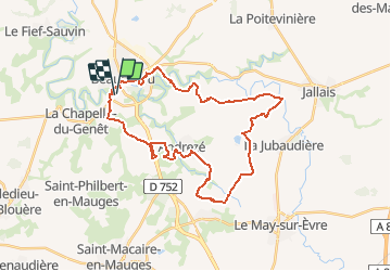

Length
34 km

Max alt
118 m

Uphill gradient
437 m
Km-Effort
40 km

Min alt
49 m

Downhill gradient
437 m
Boucle
Yes
Creation date :
2016-10-18 00:00:00.0
Updated on :
2016-10-18 00:00:00.0
--
Difficulty : Medium

FREE GPS app for hiking
 SityTrail
IGN / Geographical institutes
SityTrail Plus
The world is yours!
About
Trail Mountain bike of 34 km to be discovered at Pays de la Loire, Maine-et-Loire, Beaupréau-en-Mauges. This trail is proposed by funkady.
Positioning
Country:
France
Region :
Pays de la Loire
Department/Province :
Maine-et-Loire
Municipality :
Beaupréau-en-Mauges
Location:
Beaupréau
Start:(Dec)
Start:(UTM)
651829 ; 5228695 (30T) N.
Comments