


Luciolette 2016

mthomas30
User
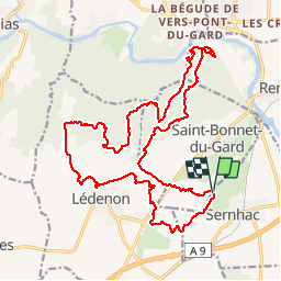

Length
24 km

Max alt
203 m

Uphill gradient
487 m
Km-Effort
31 km

Min alt
27 m

Downhill gradient
491 m
Boucle
Yes
Creation date :
2017-05-03 00:00:00.0
Updated on :
2017-05-03 00:00:00.0
1h59
Difficulty : Medium

FREE GPS app for hiking
 SityTrail
IGN / Geographical institutes
SityTrail Plus
The world is yours!
About
Trail Mountain bike of 24 km to be discovered at Occitania, Gard, Sernhac. This trail is proposed by mthomas30.
Description
Rando VTT nocturne, départ du pont du Gard ou de St Bonnet.
Positioning
Country:
France
Region :
Occitania
Department/Province :
Gard
Municipality :
Sernhac
Location:
Unknown
Start:(Dec)
Start:(UTM)
624038 ; 4863732 (31T) N.
Comments