Trail Walking Saint-Thomas - st thomas long - Photo
 pidjam
pidjam

User

© OpenStreetMap contributors
Length
Length
12.1 km
Max alt
Max alt
325 m
Uphill gradient
Uphill gradient
273 m
Km-Effort
Km-Effort  
15.8 km
Min alt
Min alt
182 m
Downhill gradient
Downhill gradient
272 m
Boucle
Boucle
Yes
Creation date :
2016-10-22 00:00:00.0
Updated on :
2016-10-22 00:00:00.0

(0 Reviews)

Walking
Walking
3h22
Difficulty : Easy

Scan this QR Code to open this trail in the SityTrail application

FREE GPS app for hiking

Logo SityTrail SityTrail

IGN / Geographical institutes

Download SityTrail from the App Store Download SityTrail from Google Play

Logo SityTrail SityTrail World

The world is yours!

Download SityTrail from the App Store Download SityTrail from Google Play Download SityTrail on Huawei AppGallery

About

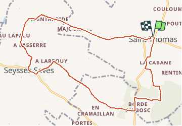
Trail Walking of 12.1 km to be discovered at Occitania, Haute-Garonne, Saint-Thomas. This trail is proposed by pidjam.

Description

marche sympa dans la campagne autour de St Thomas et Seysses-Savès (2015)

Elevation profile

Positioning

Country:
France
Region :
Occitania
Department/Province :
Haute-Garonne
Municipality :
Saint-Thomas
Location:
Unknown
Start:(UTM)
345055 ; 4819766 (31T) N.

Trails nearby

Trail Walking Saiguède - Raide de Saiguède - Photo
Walking
tracegps

Walking

Difficult
(1)
Saiguède, Occitania, Haute-Garonne, France
19 km | 23 km-effort
4h 0min
Yes
Trail Walking Sainte-Foy-de-Peyrolières - Lac et bois autour de Sainte Foy de Peyrolières - Photo
Walking
tracegps

Walking

Easy
Sainte-Foy-de-Peyrolières, Occitania, Haute-Garonne, France
9 km | 11.2 km-effort
2h 30min
Yes
Trail Walking Sainte-Foy-de-Peyrolières - Ste Foy de Peyrolières 13 Avril 2020 - Photo
Walking
daniel3157

Walking

Easy
Sainte-Foy-de-Peyrolières, Occitania, Haute-Garonne, France
16.4 km | 21 km-effort
4h 58min
Yes
Trail Running Saiguède - Raide de Saiguède - Photo
Running
tracegps

Running

Very difficult
Saiguède, Occitania, Haute-Garonne, France
19 km | 23 km-effort
2h 0min
Yes
Trail Walking Sainte-Foy-de-Peyrolières - Randonnée Sainte Foy de Peyrolières  - Photo
Walking
Fafou64

Walking

Sainte-Foy-de-Peyrolières, Occitania, Haute-Garonne, France
10.7 km | 12.9 km-effort
2h 39min
Yes
Trail Walking Saiguède - Saiguède belles vues - Photo
Walking
pidjam

Walking

Very easy
Saiguède, Occitania, Haute-Garonne, France
8.3 km | 10.5 km-effort
2h 0min
Yes
Trail Walking Empeaux - Empeaux circuit cross - Photo
Walking
pidjam

Walking

Easy
Empeaux, Occitania, Haute-Garonne, France
9.7 km | 12.5 km-effort
2h 40min
Yes
Trail Cycle Sainte-Foy-de-Peyrolières - V003-Tour LASSERRE - Photo
Cycle
Polo-31

Cycle

Difficult
Sainte-Foy-de-Peyrolières, Occitania, Haute-Garonne, France
141 km | 163 km-effort
6h 0min
Yes
Trail Cycle Sainte-Foy-de-Peyrolières - V002-Ste Foy Col de la Core - Photo
Cycle
Polo-31

Cycle

Difficult
Sainte-Foy-de-Peyrolières, Occitania, Haute-Garonne, France
223 km | 260 km-effort
14h 46min
Yes


Close
My subscriptions