Trail Walking Mouzillon - Mouzillon - Photo
 Delgorge
Delgorge

User

© OpenStreetMap contributors
Length
Length
9 km
Max alt
Max alt
44 m
Uphill gradient
Uphill gradient
75 m
Km-Effort
Km-Effort  
10 km
Min alt
Min alt
11 m
Downhill gradient
Downhill gradient
79 m
Boucle
Boucle
Yes
Creation date :
2016-11-21 00:00:00.0
Updated on :
2016-11-21 00:00:00.0

(0 Reviews)

Walking
Walking
2h14
Difficulty : Easy

Scan this QR Code to open this trail in the SityTrail application

FREE GPS app for hiking

Logo SityTrail SityTrail

IGN / Geographical institutes

Download SityTrail from the App Store Download SityTrail from Google Play

Logo SityTrail SityTrail World

The world is yours!

Download SityTrail from the App Store Download SityTrail from Google Play Download SityTrail on Huawei AppGallery

About

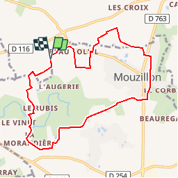
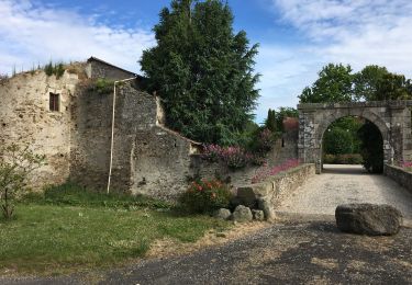
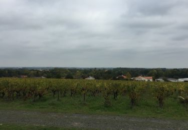
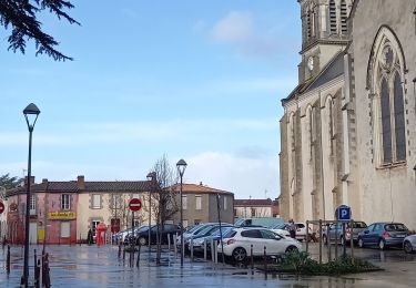
Trail Walking of 9 km to be discovered at Pays de la Loire, Loire-Atlantique, Mouzillon. This trail is proposed by Delgorge.

Description

Parcours dans les vignes au départ de l'Eglise St Martin

Elevation profile

Points of interest

Point of interest Mouzillon -  - Photo
Delgorge
MOUZILLON 

Positioning

Country:
France
Region :
Pays de la Loire
Department/Province :
Loire-Atlantique
Municipality :
Mouzillon
Location:
Unknown
Start:(UTM)
628482 ; 5222578 (30T) N.

Trails nearby

Trail Mountain bike Monnières - Sèvre et Maine - Monnières - Photo
Mountain bike
tracegps

Mountain bike

Difficult
(1)
Monnières, Pays de la Loire, Loire-Atlantique, France
34 km | 39 km-effort
2h 30min
Yes
Trail Walking Le Pallet - Le pallet - Photo
Walking
Lobin

Walking

Easy
Le Pallet, Pays de la Loire, Loire-Atlantique, France
8.8 km | 9.8 km-effort
316h 56min
Yes
Trail Other activity Monnières - Monnieres (44) - Photo
Other activity
bellicaud

Other activity

Easy
Monnières, Pays de la Loire, Loire-Atlantique, France
8 km | 9.1 km-effort
2h 2min
Yes
Trail Walking Monnières - Monnieres  Clisson - Photo
Walking
yves le sommer

Walking

Medium
Monnières, Pays de la Loire, Loire-Atlantique, France
10 km | 11.1 km-effort
2h 37min
No
Trail Walking La Chapelle-Heulin - La Chapelle-Heulin 14km - Photo
Walking
Lobin

Walking

Difficult
La Chapelle-Heulin, Pays de la Loire, Loire-Atlantique, France
14 km | 15 km-effort
2h 24min
Yes
Trail Walking Vallet - Vallet- nord-est - Photo
Walking
TEFFRA

Walking

Easy
Vallet, Pays de la Loire, Loire-Atlantique, France
8.6 km | 9.5 km-effort
2h 6min
Yes
Trail Walking Vallet - Vallet - Les coteaux - Photo
Walking
TEFFRA

Walking

Easy
Vallet, Pays de la Loire, Loire-Atlantique, France
9.2 km | 10.5 km-effort
2h 18min
Yes
Trail Walking Vallet - Vallet - Château de la Noë - Photo
Walking
TEFFRA

Walking

Easy
Vallet, Pays de la Loire, Loire-Atlantique, France
9.1 km | 10.2 km-effort
2h 15min
Yes
Trail Walking Monnières - Monnières - sud-est pique-nique - Photo
Walking
TEFFRA

Walking

Medium
Monnières, Pays de la Loire, Loire-Atlantique, France
8.2 km | 9.1 km-effort
2h 1min
Yes


Close
My subscriptions