Trail Walking Lyon - A_LYON 69002 Berges de Saône - Photo

A_LYON 69002 Berges de Saône

 ANDREJAC
ANDREJAC

User

© OpenStreetMap contributors
Length
Length
10.5 km
Max alt
Max alt
192 m
Uphill gradient
Uphill gradient
124 m
Km-Effort
Km-Effort  
12.2 km
Min alt
Min alt
160 m
Downhill gradient
Downhill gradient
124 m
Boucle
Boucle
No
Creation date :
2016-11-24 00:00:00.0
Updated on :
2016-11-24 00:00:00.0

(0 Reviews)

Walking
Walking
3h00
Difficulty : Very easy

Scan this QR Code to open this trail in the SityTrail application

FREE GPS app for hiking

Logo SityTrail SityTrail

IGN / Geographical institutes

Download SityTrail from the App Store Download SityTrail from Google Play

Logo SityTrail SityTrail World

The world is yours!

Download SityTrail from the App Store Download SityTrail from Google Play Download SityTrail on Huawei AppGallery

About

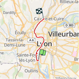
Trail Walking of 10.5 km to be discovered at Auvergne-Rhône-Alpes, Métropole de Lyon, Lyon. This trail is proposed by ANDREJAC.

Description

Départ du Pont Pasteur rive droite, arrêt du tramway T1.
Remontée de la Saône rive gauche jusqu'à l'Ile Barbe.
Franchissement de la Saône par le pont de l'Ile Barbe.

Elevation profile

Positioning

Country:
France
Region :
Auvergne-Rhône-Alpes
Department/Province :
Métropole de Lyon
Municipality :
Lyon
Location:
Lyon 2e Arrondissement
Start:(UTM)
641511 ; 5066061 (31T) N.

Trails nearby

Trail Walking Lyon - 69-Lyon-murs-peints-musée-Tony-Garnier-mai21 - Photo
Walking
SyMA

Walking

Easy
(1)
Lyon, Auvergne-Rhône-Alpes, Métropole de Lyon, France
3.7 km | 4 km-effort
1h 37min
Yes
Trail Mountain bike Lyon - Mont Verdun - Photo
Mountain bike
tracegps

Mountain bike

Difficult
(2)
Lyon, Auvergne-Rhône-Alpes, Métropole de Lyon, France
29 km | 37 km-effort
2h 15min
Yes
Trail Walking Lyon - De Place des Archives à Monplaisir - Photo
Walking
Marie-Hélène Luton 2

Walking

Difficult
(1)
Lyon, Auvergne-Rhône-Alpes, Métropole de Lyon, France
11.2 km | 12.9 km-effort
2h 55min
No
Trail Walking Francheville - Aqueduc et fort du Bruissin (PR1) - Photo
Walking
chuck

Walking

Easy
Francheville, Auvergne-Rhône-Alpes, Métropole de Lyon, France
19.1 km | 23 km-effort
5h 20min
Yes
Trail Walking Chaponost - de Chaponost à Brignais AR - Photo
Walking
maclobar

Walking

Difficult
Chaponost, Auvergne-Rhône-Alpes, Rhône, France
11.8 km | 14.3 km-effort
2h 40min
Yes
Trail Walking Chaponost - Chaponost boucle - Photo
Walking
maclobar

Walking

Medium
Chaponost, Auvergne-Rhône-Alpes, Rhône, France
9.2 km | 11.2 km-effort
1h 56min
Yes
Trail Walking Chaponost - Acqueducs de Chaponost à Beaunant - Photo
Walking
maclobar

Walking

Medium
Chaponost, Auvergne-Rhône-Alpes, Rhône, France
7 km | 9.2 km-effort
1h 35min
Yes
Trail Walking Sainte-Foy-lès-Lyon - Sainte foy les lyon - Photo
Walking
daniellebou

Walking

Difficult
(1)
Sainte-Foy-lès-Lyon, Auvergne-Rhône-Alpes, Métropole de Lyon, France
9.9 km | 13.2 km-effort
2h 52min
Yes
Trail Walking Lyon - Fnac - Photo
Walking
ricoux

Walking

Easy
(1)
Lyon, Auvergne-Rhône-Alpes, Métropole de Lyon, France
1.9 km | 2.3 km-effort
18min
No


Close
My subscriptions