Mervent

Lobin
User

Length
8.2 km

Max alt
110 m

Uphill gradient
177 m
Km-Effort
10.5 km

Min alt
40 m

Downhill gradient
179 m
Boucle
Yes
Creation date :
2016-10-26 00:00:00.0
Updated on :
2016-10-26 00:00:00.0
1h55
Difficulty : Easy

FREE GPS app for hiking
 SityTrail
IGN / Geographical institutes
SityTrail Plus
The world is yours!
About
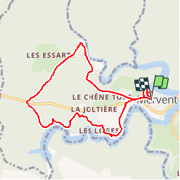
Trail Walking of 8.2 km to be discovered at Pays de la Loire, Vendée, Mervent. This trail is proposed by Lobin.
Description
randonnée au bord du cours d'eau et de la foret
Positioning
Country:
France
Region :
Pays de la Loire
Department/Province :
Vendée
Municipality :
Mervent
Location:
Unknown
Start:(Dec)
Start:(UTM)
672060 ; 5154639 (30T) N.
Comments