


chalet de Lioraz du Buet

olivieraron
User
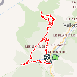

Length
10.9 km

Max alt
2017 m

Uphill gradient
709 m
Km-Effort
20 km

Min alt
1344 m

Downhill gradient
709 m
Boucle
Yes
Creation date :
2019-01-14 09:43:54.829
Updated on :
2019-01-14 09:43:55.01
5h00
Difficulty : Unknown

FREE GPS app for hiking
 SityTrail
IGN / Geographical institutes
SityTrail Plus
The world is yours!
About
Trail Other activity of 10.9 km to be discovered at Auvergne-Rhône-Alpes, Upper Savoy, Vallorcine. This trail is proposed by olivieraron.
Positioning
Country:
France
Region :
Auvergne-Rhône-Alpes
Department/Province :
Upper Savoy
Municipality :
Vallorcine
Location:
Unknown
Start:(Dec)
Start:(UTM)
338964 ; 5098218 (32T) N.
Comments