


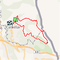
Castellar-Mont Carpano 30-10-2016

fredetpascale
User GUIDE

Length
9.4 km

Max alt
787 m

Uphill gradient
530 m
Km-Effort
16.5 km

Min alt
324 m

Downhill gradient
524 m
Boucle
Yes
Creation date :
2016-10-31 00:00:00.0
Updated on :
2016-10-31 00:00:00.0
3h05
Difficulty : Easy

FREE GPS app for hiking
 SityTrail
IGN / Geographical institutes
SityTrail Plus
The world is yours!
About
Trail Walking of 9.4 km to be discovered at Provence-Alpes-Côte d'Azur, Maritime Alps, Castellar. This trail is proposed by fredetpascale.
Positioning
Country:
France
Region :
Provence-Alpes-Côte d'Azur
Department/Province :
Maritime Alps
Municipality :
Castellar
Location:
Unknown
Start:(Dec)
Start:(UTM)
379080 ; 4851329 (32T) N.
Comments