


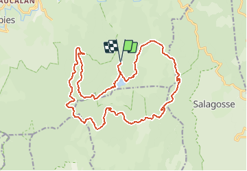
Gard - Le Lac des Pises 22km 373m

RandoVal
User


6h08
Difficulty : Medium

FREE GPS app for hiking
 SityTrail
IGN / Geographical institutes
SityTrail Plus
The world is yours!
About
Trail Walking of 22 km to be discovered at Occitania, Gard, Dourbies. This trail is proposed by RandoVal.
Description
Parcours en Cévennes Gardoise dans le massif de l'Aigoual.
Départ du parking du Lac des Pises, sens anti-horaire.Entre km11 et km13 emprunter l'ancien tracé du GR, un peu perdu dans la végétation mais plus sympa que la route forestière bétonnée au dessus .
Positioning
Comments