


69 chiroubles reel

trietsch
User
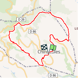

Length
10 km

Max alt
563 m

Uphill gradient
313 m
Km-Effort
14.2 km

Min alt
310 m

Downhill gradient
312 m
Boucle
Yes
Creation date :
2016-11-01 00:00:00.0
Updated on :
2020-01-04 20:29:29.857
3h48
Difficulty : Medium

FREE GPS app for hiking
 SityTrail
IGN / Geographical institutes
SityTrail Plus
The world is yours!
About
Trail Walking of 10 km to be discovered at Auvergne-Rhône-Alpes, Rhône, Chiroubles. This trail is proposed by trietsch.


Positioning
Country:
France
Region :
Auvergne-Rhône-Alpes
Department/Province :
Rhône
Municipality :
Chiroubles
Location:
Unknown
Start:(Dec)
Start:(UTM)
628518 ; 5115403 (31T) N.
Comments