


pont des sarrasins

JACQUES.FUMAT
User
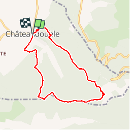

Length
8.6 km

Max alt
782 m

Uphill gradient
489 m
Km-Effort
15.1 km

Min alt
375 m

Downhill gradient
480 m
Boucle
Yes
Creation date :
2016-11-01 00:00:00.0
Updated on :
2016-11-01 00:00:00.0
3h15
Difficulty : Medium

FREE GPS app for hiking
 SityTrail
IGN / Geographical institutes
SityTrail Plus
The world is yours!
About
Trail Walking of 8.6 km to be discovered at Auvergne-Rhône-Alpes, Drôme, Châteaudouble. This trail is proposed by JACQUES.FUMAT.
Positioning
Country:
France
Region :
Auvergne-Rhône-Alpes
Department/Province :
Drôme
Municipality :
Châteaudouble
Location:
Unknown
Start:(Dec)
Start:(UTM)
665493 ; 4973887 (31T) N.
Comments
Très belle balade avec sentiers praticables sans trop de dificultées,cerise sur le gâteau, cette belle arche des SARRASINS et ses petites grottes en périphérie et une vue splendide sur la plaine .