


2 11 2016 parc Tejada Almijara

jpipacific
User
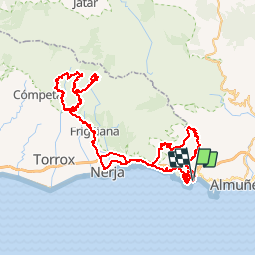

Length
116 km

Max alt
978 m

Uphill gradient
4203 m
Km-Effort
172 km

Min alt
24 m

Downhill gradient
4202 m
Boucle
Yes
Creation date :
2017-12-12 00:00:00.0
Updated on :
2019-09-09 12:45:45.223
4h20
Difficulty : Difficult

FREE GPS app for hiking
 SityTrail
IGN / Geographical institutes
SityTrail Plus
The world is yours!
About
Trail Moto cross of 116 km to be discovered at Andalusia, Granada, Almuñécar. This trail is proposed by jpipacific.
Description
Magnifiques paysages
Photos


Positioning
Country:
Spain
Region :
Andalusia
Department/Province :
Granada
Municipality :
Almuñécar
Location:
Unknown
Start:(Dec)
Start:(UTM)
432096 ; 4066031 (30S) N.
Comments