


val de mosson - St Jean

philcll
User
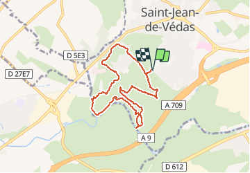

Length
8 km

Max alt
57 m

Uphill gradient
132 m
Km-Effort
9.7 km

Min alt
13 m

Downhill gradient
130 m
Boucle
Yes
Creation date :
2016-11-04 00:00:00.0
Updated on :
2016-11-04 00:00:00.0
2h07
Difficulty : Easy

FREE GPS app for hiking
 SityTrail
IGN / Geographical institutes
SityTrail Plus
The world is yours!
About
Trail Walking of 8 km to be discovered at Occitania, Hérault, Saint-Jean-de-Védas. This trail is proposed by philcll.
Positioning
Country:
France
Region :
Occitania
Department/Province :
Hérault
Municipality :
Saint-Jean-de-Védas
Location:
Unknown
Start:(Dec)
Start:(UTM)
566396 ; 4823989 (31T) N.
Comments