


sancerre 7 km

rvapeldo
User GUIDE
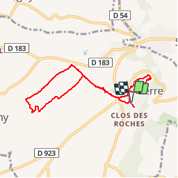

Length
7.7 km

Max alt
303 m

Uphill gradient
209 m
Km-Effort
10.4 km

Min alt
176 m

Downhill gradient
210 m
Boucle
Yes
Creation date :
2018-10-06 08:28:52.995
Updated on :
2018-10-06 08:28:53.309
1h55
Difficulty : Easy

FREE GPS app for hiking
 SityTrail
IGN / Geographical institutes
SityTrail Plus
The world is yours!
About
Trail Walking of 7.7 km to be discovered at Centre-Loire Valley, Cher, Sancerre. This trail is proposed by rvapeldo.
Positioning
Country:
France
Region :
Centre-Loire Valley
Department/Province :
Cher
Municipality :
Sancerre
Location:
Unknown
Start:(Dec)
Start:(UTM)
487664 ; 5241701 (31T) N.
Comments