


st remy B

olivieraron
User
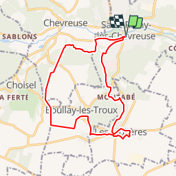

Length
16 km

Max alt
182 m

Uphill gradient
242 m
Km-Effort
19.2 km

Min alt
77 m

Downhill gradient
242 m
Boucle
Yes
Creation date :
2019-01-14 09:43:53.521
Updated on :
2019-01-14 09:43:53.554
9m
Difficulty : Unknown

FREE GPS app for hiking
 SityTrail
IGN / Geographical institutes
SityTrail Plus
The world is yours!
About
Trail Other activity of 16 km to be discovered at Ile-de-France, Yvelines, Saint-Rémy-lès-Chevreuse. This trail is proposed by olivieraron.
Positioning
Country:
France
Region :
Ile-de-France
Department/Province :
Yvelines
Municipality :
Saint-Rémy-lès-Chevreuse
Location:
Unknown
Start:(Dec)
Start:(UTM)
431658 ; 5394875 (31U) N.
Comments