


Herault - St-Maurice-de-Navacelles les Rajols 14km 222m

RandoVal
User
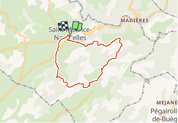

Length
13.5 km

Max alt
672 m

Uphill gradient
263 m
Km-Effort
17 km

Min alt
531 m

Downhill gradient
262 m
Boucle
Yes
Creation date :
2018-09-12 19:08:58.528
Updated on :
2020-06-22 07:16:18.468
3h43
Difficulty : Easy

FREE GPS app for hiking
 SityTrail
IGN / Geographical institutes
SityTrail Plus
The world is yours!
About
Trail Walking of 13.5 km to be discovered at Occitania, Hérault, Saint-Maurice-Navacelles. This trail is proposed by RandoVal.
Description
Petite rando entre la Vis et la Séranne. sens horaire. Départ parking randonneurs indiqué.
Positioning
Country:
France
Region :
Occitania
Department/Province :
Hérault
Municipality :
Saint-Maurice-Navacelles
Location:
Unknown
Start:(Dec)
Start:(UTM)
541755 ; 4854868 (31T) N.
Comments