


rando col sormiou - titou ninou - fontaine voire

mapomme
User
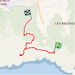

Length
7.1 km

Max alt
381 m

Uphill gradient
310 m
Km-Effort
11.5 km

Min alt
79 m

Downhill gradient
409 m
Boucle
No
Creation date :
2016-11-06 00:00:00.0
Updated on :
2016-11-06 00:00:00.0
4h55
Difficulty : Medium

FREE GPS app for hiking
 SityTrail
IGN / Geographical institutes
SityTrail Plus
The world is yours!
About
Trail Walking of 7.1 km to be discovered at Provence-Alpes-Côte d'Azur, Bouches-du-Rhône, Marseille. This trail is proposed by mapomme.
Positioning
Country:
France
Region :
Provence-Alpes-Côte d'Azur
Department/Province :
Bouches-du-Rhône
Municipality :
Marseille
Location:
8th Arrondissement
Start:(Dec)
Start:(UTM)
695588 ; 4787716 (31T) N.
Comments