


Hanvec

cron
User
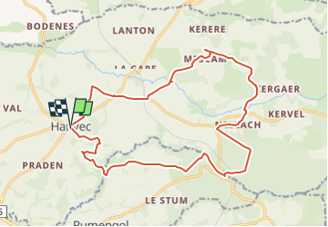

Length
19.2 km

Max alt
195 m

Uphill gradient
367 m
Km-Effort
24 km

Min alt
30 m

Downhill gradient
366 m
Boucle
Yes
Creation date :
2016-11-06 00:00:00.0
Updated on :
2024-04-29 11:37:39.419
5h11
Difficulty : Difficult

FREE GPS app for hiking
 SityTrail
IGN / Geographical institutes
SityTrail Plus
The world is yours!
About
Trail Walking of 19.2 km to be discovered at Brittany, Finistère, Hanvec. This trail is proposed by cron.
Positioning
Country:
France
Region :
Brittany
Department/Province :
Finistère
Municipality :
Hanvec
Location:
Unknown
Start:(Dec)
Start:(UTM)
414034 ; 5353285 (30U) N.
Comments