


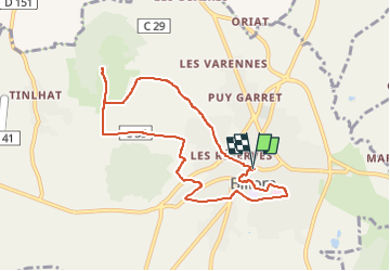
Billom_Turluron

jagarnier
User GUIDE

Length
8.4 km

Max alt
551 m

Uphill gradient
260 m
Km-Effort
11.9 km

Min alt
350 m

Downhill gradient
261 m
Boucle
Yes
Creation date :
2016-11-07 00:00:00.0
Updated on :
2023-04-08 06:24:22.309
2h30
Difficulty : Medium

FREE GPS app for hiking
 SityTrail
IGN / Geographical institutes
SityTrail Plus
The world is yours!
About
Trail Walking of 8.4 km to be discovered at Auvergne-Rhône-Alpes, Puy-de-Dôme, Billom. This trail is proposed by jagarnier.
Description
Le circuit offre des points de vue sur la chaîne des Puys et sur le patrimoine de la vallée. On découvre ce pays que l’on surnomme ici, la "Toscane auvergnate".
Photos

Positioning
Country:
France
Region :
Auvergne-Rhône-Alpes
Department/Province :
Puy-de-Dôme
Municipality :
Billom
Location:
Unknown
Start:(Dec)
Start:(UTM)
526390 ; 5063399 (31T) N.
Comments