


Trassanel Roc de L'Aigle Roc Agnel

mikaou.t
User
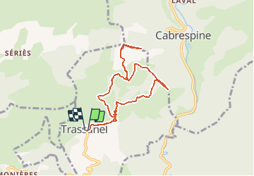

Length
8.5 km

Max alt
696 m

Uphill gradient
477 m
Km-Effort
14.9 km

Min alt
400 m

Downhill gradient
478 m
Boucle
Yes
Creation date :
2016-11-08 00:00:00.0
Updated on :
2016-11-08 00:00:00.0
3h00
Difficulty : Medium

FREE GPS app for hiking
 SityTrail
IGN / Geographical institutes
SityTrail Plus
The world is yours!
About
Trail Walking of 8.5 km to be discovered at Occitania, Aude, Trassanel. This trail is proposed by mikaou.t.
Positioning
Country:
France
Region :
Occitania
Department/Province :
Aude
Municipality :
Trassanel
Location:
Unknown
Start:(Dec)
Start:(UTM)
454332 ; 4799395 (31T) N.
Comments