


2016-11-09 Running Session PPS

holtzv
User GUIDE

Length
9.4 km

Max alt
155 m

Uphill gradient
88 m
Km-Effort
10.6 km

Min alt
137 m

Downhill gradient
90 m
Boucle
No
Creation date :
2016-11-09 00:00:00.0
Updated on :
2016-11-09 00:00:00.0
--
Difficulty : Medium

FREE GPS app for hiking
 SityTrail
IGN / Geographical institutes
SityTrail Plus
The world is yours!
About
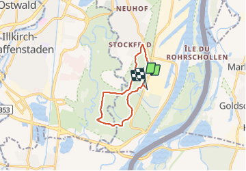
Trail Running of 9.4 km to be discovered at Grand Est, Bas-Rhin, Strasbourg. This trail is proposed by holtzv.
Positioning
Country:
France
Region :
Grand Est
Department/Province :
Bas-Rhin
Municipality :
Strasbourg
Location:
Unknown
Start:(Dec)
Start:(UTM)
409483 ; 5374360 (32U) N.
Comments