


z banlieue de Bagnols 10-11-16

cb8310
User
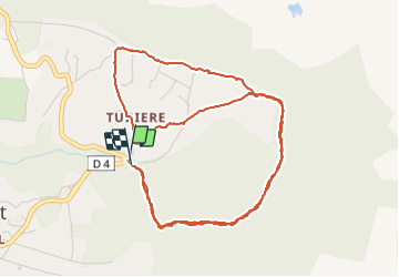

Length
6.9 km

Max alt
341 m

Uphill gradient
100 m
Km-Effort
8.2 km

Min alt
297 m

Downhill gradient
95 m
Boucle
Yes
Creation date :
2016-11-11 00:00:00.0
Updated on :
2022-03-19 16:47:01.904
1h53
Difficulty : Easy

FREE GPS app for hiking
 SityTrail
IGN / Geographical institutes
SityTrail Plus
The world is yours!
About
Trail Walking of 6.9 km to be discovered at Provence-Alpes-Côte d'Azur, Var, Bagnols-en-Forêt. This trail is proposed by cb8310.
Description
rando tranquille ,ombragée par des sentiers parfois caillouteux sans aucune difficulté
Positioning
Country:
France
Region :
Provence-Alpes-Côte d'Azur
Department/Province :
Var
Municipality :
Bagnols-en-Forêt
Location:
Unknown
Start:(Dec)
Start:(UTM)
315284 ; 4823374 (32T) N.
Comments