


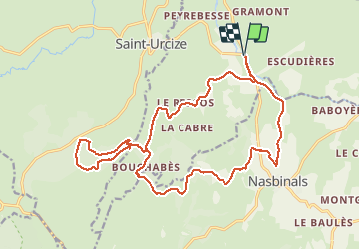
PONT DU GOURNIER 22 km VTT Nasbinals

benoit48
User

Length
22 km

Max alt
1352 m

Uphill gradient
496 m
Km-Effort
29 km

Min alt
1068 m

Downhill gradient
496 m
Boucle
Yes
Creation date :
2018-01-07 00:00:00.0
Updated on :
2018-01-07 00:00:00.0
1h25
Difficulty : Unknown

FREE GPS app for hiking
 SityTrail
IGN / Geographical institutes
SityTrail Plus
The world is yours!
About
Trail Mountain bike of 22 km to be discovered at Occitania, Lozère, Recoules-d'Aubrac. This trail is proposed by benoit48.
Positioning
Country:
France
Region :
Occitania
Department/Province :
Lozère
Municipality :
Recoules-d'Aubrac
Location:
Unknown
Start:(Dec)
Start:(UTM)
502782 ; 4948903 (31T) N.
Comments