


le cheiron

barney06
User
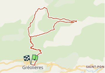

Length
15.5 km

Max alt
1764 m

Uphill gradient
952 m
Km-Effort
28 km

Min alt
839 m

Downhill gradient
954 m
Boucle
Yes
Creation date :
2016-11-12 00:00:00.0
Updated on :
2016-11-12 00:00:00.0
7h17
Difficulty : Easy

FREE GPS app for hiking
 SityTrail
IGN / Geographical institutes
SityTrail Plus
The world is yours!
About
Trail Walking of 15.5 km to be discovered at Provence-Alpes-Côte d'Azur, Maritime Alps, Gréolières. This trail is proposed by barney06.
Description
marche
Positioning
Country:
France
Region :
Provence-Alpes-Côte d'Azur
Department/Province :
Maritime Alps
Municipality :
Gréolières
Location:
Unknown
Start:(Dec)
Start:(UTM)
334487 ; 4851338 (32T) N.
Comments