


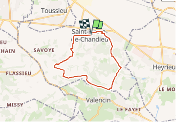
38 Saint Pierre de Chandieu

trietsch
User

Length
12.2 km

Max alt
334 m

Uphill gradient
258 m
Km-Effort
15.6 km

Min alt
243 m

Downhill gradient
258 m
Boucle
Yes
Creation date :
2018-04-12 22:34:35.619
Updated on :
2018-04-12 22:34:35.619
3h20
Difficulty : Unknown

FREE GPS app for hiking
 SityTrail
IGN / Geographical institutes
SityTrail Plus
The world is yours!
About
Trail Walking of 12.2 km to be discovered at Auvergne-Rhône-Alpes, Rhône, Saint-Pierre-de-Chandieu. This trail is proposed by trietsch.
Positioning
Country:
France
Region :
Auvergne-Rhône-Alpes
Department/Province :
Rhône
Municipality :
Saint-Pierre-de-Chandieu
Location:
Unknown
Start:(Dec)
Start:(UTM)
656727 ; 5056528 (31T) N.
Comments