


Giat_Ramade

jagarnier
User GUIDE
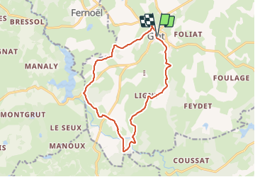

Length
14.2 km

Max alt
792 m

Uphill gradient
225 m
Km-Effort
17.2 km

Min alt
723 m

Downhill gradient
222 m
Boucle
Yes
Creation date :
2016-11-15 00:00:00.0
Updated on :
2024-05-20 08:21:15.57
4h15
Difficulty : Medium

FREE GPS app for hiking
 SityTrail
IGN / Geographical institutes
SityTrail Plus
The world is yours!
About
Trail Walking of 14.2 km to be discovered at Auvergne-Rhône-Alpes, Puy-de-Dôme, Giat. This trail is proposed by jagarnier.
Photos

Positioning
Country:
France
Region :
Auvergne-Rhône-Alpes
Department/Province :
Puy-de-Dôme
Municipality :
Giat
Location:
Unknown
Start:(Dec)
Start:(UTM)
458642 ; 5072148 (31T) N.
Comments