


Linkebeek Proxirando 27 11 2016

ThierryGABRIEL
User
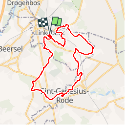

Length
18.9 km

Max alt
138 m

Uphill gradient
259 m
Km-Effort
22 km

Min alt
54 m

Downhill gradient
259 m
Boucle
Yes
Creation date :
2016-11-27 00:00:00.0
Updated on :
2016-11-27 00:00:00.0
5h32
Difficulty : Easy

FREE GPS app for hiking
 SityTrail
IGN / Geographical institutes
SityTrail Plus
The world is yours!
About
Trail Walking of 18.9 km to be discovered at Flanders, Flemish Brabant, Linkebeek. This trail is proposed by ThierryGABRIEL.
Photos


Positioning
Country:
Belgium
Region :
Flanders
Department/Province :
Flemish Brabant
Municipality :
Linkebeek
Location:
Linkebeek
Start:(Dec)
Start:(UTM)
594204 ; 5625458 (31U) N.
Comments
1ère utilisation avec une balade aux alentours de Linkebeek. J'ai encore beaucoup à apprendre mais je me suis bien débrouillé !application agréable et bien utile.