Trail Other activity Laon - Picardie - Ligne 228 - Laon - Liart - Photo

Picardie - Ligne 228 - Laon - Liart

 mich54
mich54

User

© OpenStreetMap contributors
Length
Length
59 km
Max alt
Max alt
248 m
Uphill gradient
Uphill gradient
474 m
Km-Effort
Km-Effort  
65 km
Min alt
Min alt
68 m
Downhill gradient
Downhill gradient
330 m
Boucle
Boucle
No
Creation date :
2016-11-27 00:00:00.0
Updated on :
2016-11-27 00:00:00.0

(0 Reviews)

Other activity
Other activity
5m
Difficulty : Unknown

Scan this QR Code to open this trail in the SityTrail application

FREE GPS app for hiking

Logo SityTrail SityTrail

IGN / Geographical institutes

Download SityTrail from the App Store Download SityTrail from Google Play

Logo SityTrail SityTrail World

The world is yours!

Download SityTrail from the App Store Download SityTrail from Google Play Download SityTrail on Huawei AppGallery

About

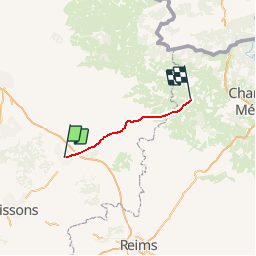
Trail Other activity of 59 km to be discovered at Hauts-de-France, Aisne, Laon. This trail is proposed by mich54.

Description

La ligne de Laon à Liart est une ligne de chemin de fer, partiellement déclassée, des départements de l'Aisne et des Ardennes.
Elle constitue la ligne no 228 000 du réseau ferré national.
Elle a été fermée au service des voyageurs en totalité le 28 septembre 1969 et au service des marchandises peu après entre Rozoy-sur-Serre et Liart et le 30 mars 1994 entre Montcornet et Rozoy-sur-Serre. Cette partie de la ligne a été déclassée en 2 étapes :
   le 24 février 19753 entre Rozoy-sur-Serre et Liart (PK 185,000 à 199,160).
   le 10 avril 19964 entre Moncornet et Rozoy-sur-Serre (PK 174,150 à 185,000).(Source Wikipédia)

Elevation profile

Positioning

Country:
France
Region :
Hauts-de-France
Department/Province :
Aisne
Municipality :
Laon
Location:
Unknown
Start:(UTM)
545163 ; 5491159 (31U) N.

Trails nearby

Trail Walking Laon - La Butte de Laon - L'eau de bas en haut - Photo
Walking
tracegps

Walking

Medium
(1)
Laon, Hauts-de-France, Aisne, France
5.4 km | 7.1 km-effort
2h 0min
Yes
Trail Walking Laon - La campagne dans la ville - Photo
Walking

Walking

Very easy
Laon, Hauts-de-France, Aisne, France
4.6 km | 6.3 km-effort
Unknown
Yes
Trail Walking Laon - RANDO A LAON  - Photo
Walking
Marc Launay

Walking

Medium
Laon, Hauts-de-France, Aisne, France
7.3 km | 9.5 km-effort
3h 4min
No
Trail Walking Laon - Le grand tour de Laon - Photo
Walking
Diogene99

Walking

Medium
Laon, Hauts-de-France, Aisne, France
7.1 km | 9.1 km-effort
2h 0min
Yes
Trail Walking Aulnois-sous-Laon - Les monts fendus - Photo
Walking
tracegps

Walking

Very easy
Aulnois-sous-Laon, Hauts-de-France, Aisne, France
22 km | 23 km-effort
6h 0min
Yes
Trail Walking Laon - Les remparts - Photo
Walking
tracegps

Walking

Medium
(1)
Laon, Hauts-de-France, Aisne, France
5.6 km | 6.6 km-effort
2h 0min
Yes
Trail Walking Laon - La campagne dans la ville - Photo
Walking
tracegps

Walking

Medium
Laon, Hauts-de-France, Aisne, France
4.6 km | 6.3 km-effort
1h 30min
Yes
Trail Walking Laon - Laon cité médiévale - Photo
Walking
gdela

Walking

Easy
Laon, Hauts-de-France, Aisne, France
2.8 km | 3.3 km-effort
47min
Yes
Trail Walking Laon - Laon - Neuville sur Ailette  - Photo
Walking
VANDERPUTTENMi

Walking

Very easy
Laon, Hauts-de-France, Aisne, France
20 km | 24 km-effort
5h 6min
No


Close
My subscriptions