


Corronsac.Montbrun

pidjam
User
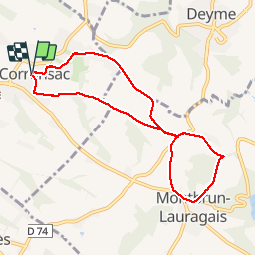

Length
8.2 km

Max alt
284 m

Uphill gradient
171 m
Km-Effort
10.5 km

Min alt
199 m

Downhill gradient
170 m
Boucle
Yes
Creation date :
2016-12-29 00:00:00.0
Updated on :
2016-12-29 00:00:00.0
2h16
Difficulty : Very easy

FREE GPS app for hiking
 SityTrail
IGN / Geographical institutes
SityTrail Plus
The world is yours!
About
Trail Walking of 8.2 km to be discovered at Occitania, Haute-Garonne, Corronsac. This trail is proposed by pidjam.
Description
Petite marche sur les coteaux du Lauragais.
Photos


Positioning
Country:
France
Region :
Occitania
Department/Province :
Haute-Garonne
Municipality :
Corronsac
Location:
Unknown
Start:(Dec)
Start:(UTM)
378279 ; 4814501 (31T) N.
Comments