


la garonette de christian

bernir
User

Length
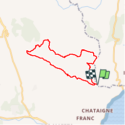
13.8 km

Max alt
291 m

Uphill gradient
444 m
Km-Effort
19.8 km

Min alt
18 m

Downhill gradient
443 m
Boucle
Yes
Creation date :
2016-12-02 00:00:00.0
Updated on :
2016-12-02 00:00:00.0
6h37
Difficulty : Easy

FREE GPS app for hiking
 SityTrail
IGN / Geographical institutes
SityTrail Plus
The world is yours!
About
Trail Walking of 13.8 km to be discovered at Provence-Alpes-Côte d'Azur, Var, Roquebrune-sur-Argens. This trail is proposed by bernir.
Description
La mer du Cap taillat jusqu'à Cap Esterel
Positioning
Country:
France
Region :
Provence-Alpes-Côte d'Azur
Department/Province :
Var
Municipality :
Roquebrune-sur-Argens
Location:
Unknown
Start:(Dec)
Start:(UTM)
310494 ; 4801658 (32T) N.
Comments