


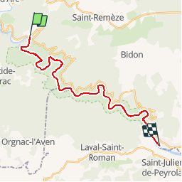
Randonnée des gorges de l'ardèche
© OpenStreetMap contributors


--
Difficulty : Difficult


Length
23 km
Max alt
198 m
Uphill gradient
872 m
Km-Effort
35 km
Min alt
44 m
Downhill gradient
913 m
Boucle
No
Creation date :
2014-12-10 00:00:00.0
Updated on :
2014-12-10 00:00:00.0
--
Difficulty : Difficult
FREE GPS app for hiking
 SityTrail
IGN / Geographical institutes
SityTrail Plus
The world is yours!
About
Trail Walking of 23 km to be discovered at Auvergne-Rhône-Alpes, Ardèche, Vallon-Pont-d'Arc. This trail is proposed by maxime.ranchin@aliceadsl.fr.


Positioning
Country:
France
Region :
Auvergne-Rhône-Alpes
Department/Province :
Ardèche
Municipality :
Vallon-Pont-d'Arc
Location:
Unknown
Start:(Dec)
Start:(UTM)
614394 ; 4914957 (31T) N.
Comments