


lions 2

fredspa
User
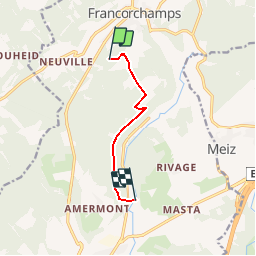

Length
5.3 km

Max alt
547 m

Uphill gradient
49 m
Km-Effort
6.6 km

Min alt
313 m

Downhill gradient
257 m
Boucle
No
Creation date :
2014-12-10 00:00:00.0
Updated on :
2014-12-10 00:00:00.0
--
Difficulty : Easy

FREE GPS app for hiking
 SityTrail
IGN / Geographical institutes
SityTrail Plus
The world is yours!
About
Trail Walking of 5.3 km to be discovered at Wallonia, Liège, Stavelot. This trail is proposed by fredspa.
Positioning
Country:
Belgium
Region :
Wallonia
Department/Province :
Liège
Municipality :
Stavelot
Location:
Francorchamps
Start:(Dec)
Start:(UTM)
709047 ; 5592015 (31U) N.
Comments