


pic des mouches prieuré

bernir
User
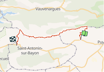

Length
12.3 km

Max alt
999 m

Uphill gradient
812 m
Km-Effort
23 km

Min alt
310 m

Downhill gradient
904 m
Boucle
No
Creation date :
2016-12-03 00:00:00.0
Updated on :
2016-12-03 00:00:00.0
4h39
Difficulty : Difficult

FREE GPS app for hiking
 SityTrail
IGN / Geographical institutes
SityTrail Plus
The world is yours!
About
Trail Walking of 12.3 km to be discovered at Provence-Alpes-Côte d'Azur, Bouches-du-Rhône, Puyloubier. This trail is proposed by bernir.
Description
montée par St Ser vers le goufre de Cagolou; descente par le pas de l'escalette vers le pont de l'anchois
Positioning
Country:
France
Region :
Provence-Alpes-Côte d'Azur
Department/Province :
Bouches-du-Rhône
Municipality :
Puyloubier
Location:
Unknown
Start:(Dec)
Start:(UTM)
713590 ; 4822831 (31T) N.
Comments