


chapelle taulisson jouques

patrickmays3
User
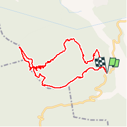

Length
12.5 km

Max alt
771 m

Uphill gradient
479 m
Km-Effort
18.9 km

Min alt
376 m

Downhill gradient
478 m
Boucle
Yes
Creation date :
2016-12-03 00:00:00.0
Updated on :
2016-12-03 00:00:00.0
3h50
Difficulty : Unknown

FREE GPS app for hiking
 SityTrail
IGN / Geographical institutes
SityTrail Plus
The world is yours!
About
Trail Walking of 12.5 km to be discovered at Provence-Alpes-Côte d'Azur, Bouches-du-Rhône, Jouques. This trail is proposed by patrickmays3.
Positioning
Country:
France
Region :
Provence-Alpes-Côte d'Azur
Department/Province :
Bouches-du-Rhône
Municipality :
Jouques
Location:
Unknown
Start:(Dec)
Start:(UTM)
713335 ; 4829816 (31T) N.
Comments