cuou de peyrou

mic-13
User
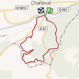

Length
7.9 km

Max alt
333 m

Uphill gradient
232 m
Km-Effort
11 km

Min alt
164 m

Downhill gradient
236 m
Boucle
Yes
Creation date :
2016-12-05 00:00:00.0
Updated on :
2016-12-05 00:00:00.0
--
Difficulty : Easy

FREE GPS app for hiking
 SityTrail
IGN / Geographical institutes
SityTrail Plus
The world is yours!
About
Trail Walking of 7.9 km to be discovered at Provence-Alpes-Côte d'Azur, Bouches-du-Rhône, Charleval. This trail is proposed by mic-13.
Positioning
Country:
France
Region :
Provence-Alpes-Côte d'Azur
Department/Province :
Bouches-du-Rhône
Municipality :
Charleval
Location:
Unknown
Start:(Dec)
Start:(UTM)
681060 ; 4842566 (31T) N.
Comments