


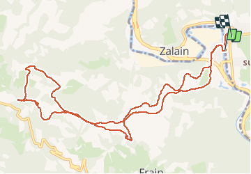
BERA-MÉGALITHES DE AMARGUNKO

DECHAMPD
User


4h44
Difficulty : Very easy

FREE GPS app for hiking
 SityTrail
IGN / Geographical institutes
SityTrail Plus
The world is yours!
About
Trail Walking of 14.7 km to be discovered at Navarre, Unknown, Lesaka. This trail is proposed by DECHAMPD.
Description
BERA-MÉGALITHES DE AMARGUNKO
Cet itinéraire suit une section du GR-11 et conduit à un dolmen et cromlech. Aussi la Couronne le sommet de Meakako gaina.
CARTE, PLUS D’INFORMATIONS ET L’ITINÉRAIRE ÉTAPE PAR ÉTAPE SUR :
http://arqueologianavarra.blogspot.com.es/2013/06/Bera-megalitos-amargunko-Lepoa.html
Photos


Positioning
Comments